Jim Baker, Perth, WA
The concept of a walk across the top of England was the brainchild of the late Alfred Wainwright, possibly England’s best known writer of walking guides. Wainwright was a complex personality; he who would disappear for days on end into the countryside, re-emerge to write up his notes of his walks, eat a meal with his long suffering wife and then vanish again into the mists atop the fells.
He was disdainful of signposting and when he produced his book on the Coast to Coast Walk in the early 1970s he made it clear that this was not a track, picked out by signposts, but rather a suggestion of ways in which walkers could traverse the country, with no hard and fast trail to follow. The walk makes use of a series of some marked trails and some less obvious ones. The way marking is eccentric at times and non-existent at others, but what are clearly designated are the start and finish points; St Bee’s in the west and Robin Hood’s Bay in the east.

Convention requires walkers to dip a boot in the Irish Sea at St Bees and pick up a pebble from the beach. At the end of the walk you dip your boot in the North Sea and drop the pebble on the beach at Robin Hood’s Bay. I used an accommodation and baggage moving service; that is to say my luggage was transported ahead of me and I stayed in designated accommodation each night, walking with a daypack.
Most people do this; to carry a full pack and camp is extremely arduous and only for the young and brave. I elected to do the walk in eleven days; the average is fourteen, mad men do it in seven and some amble along and take three weeks. That’s the beauty of the Coast to Coast, like the Bibbulmun Track, you can walk it in your own time.

So on a cold, dry English summer day I set off around the headland from St Bees.
The first four days of the trek are in the Lake District, arguably the most beautiful part of the British Isles, but also fickle where weather is concerned. Day one was seductively easy, around the headland to Ennerdale to the great hospitality of Yew Craggs B&B.
Any account of a Coast to Coast walk must mention the legendary full English breakfast. At Yew Craggs I was presented with two huge rashers of bacon, two fried eggs, a slice of fried bread, mushrooms, tomatoes, two sausages, a slice of black pudding, toast, coffee, marmalade, jam and honey; sadly no Vegemite. I thoroughly enjoyed it, although askance at the huge cholesterol intake.
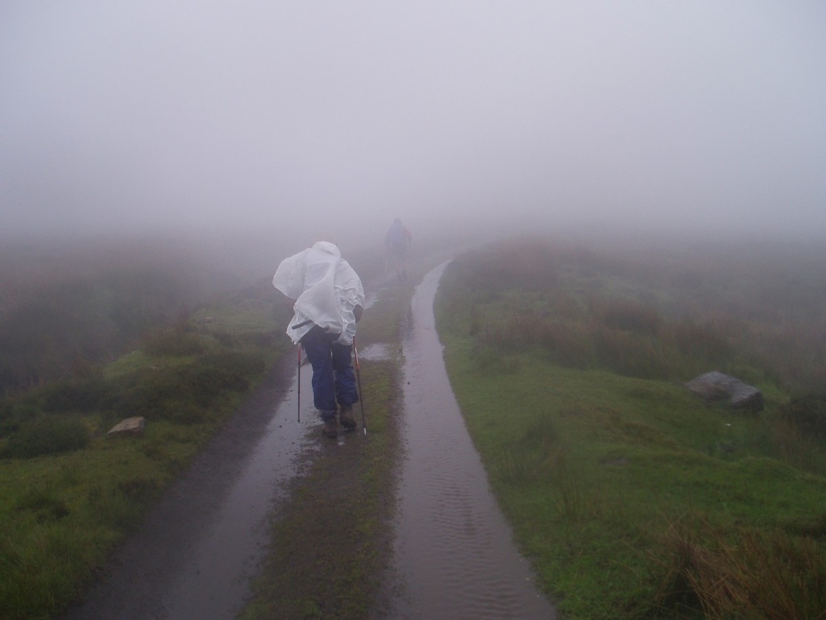
From Ennerdale the weather went foul and the walk up to Rosthwaite was hard, with heavy rain, fog and cold winds. First stop for a very welcome hot coffee was the Black Sail Youth Hostel, generally considered as the most remote of its kind in Britain.

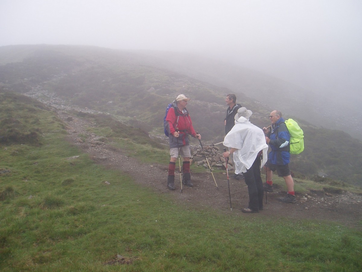
Then it was up into the clouds, clambering over slippery rocks and crossing streams on stepping stones. There were five of us together now, and it took everyone’s concentration to keep us on the right track. Not a place to walk alone, with no signage other than cairns, which are difficult to spot. There was much discussion about the route to follow to the highest point, the aptly named Grey Knotts.
Beyond Rosthwaite the conditions eased somewhat, although the climb to Patterdale was tough, covering some beautiful countryside. Here I had the great good fortune to link up with a Canadian couple, Ed and Lesley, whose schedule matched mine, and we agreed to walk together for the duration of the trek.

In Patterdale the White Lion pub proved to be a great place to recharge the batteries, ready for the hard slog to Shap next day. Good English ale—and another full English breakfast. I tried to be clever and requested no black pudding—so they gave me extra sausages! From Patterdale we set out across the moors to Shap via the highest point of the trek, Kidsty Pike, at 84 meters. First port of call was Angle Tarn, not difficult walking but finding the way through a mishmash of unmarked tracks was less than simple. Out came the compass.
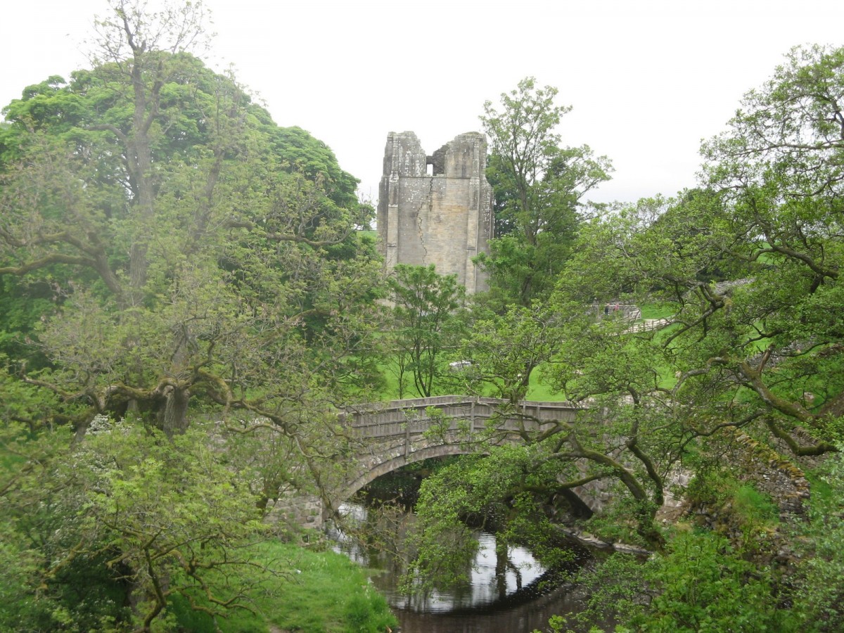
On Kidsty Pike the weather deteriorated until we were walking in a white fog. As we climbed, the fog became thicker until keeping sight of the guy in front became difficult. The descent involves a great deal of scrabbling over rocks and high steps. It was with relief that we reached Haweswater Lake, and after a long trek along the waterside the ruins of Shap Abbey were a welcome sight, as was the sight of the Kings Arms pub in Shap itself.
Now we were out of the Lake District, and the guidebook said the signage would be more consistent. Not too difficult, one imagined. On to Kirkby Stephen, a flat walk across the moors and through pasture land. The English summer day started with a temperature of four degrees, which eventually rose to a scintillating eight degrees. Couple this with a high wind across flat moorland─thank goodness for my windproof jacket! The latter part of the walk was through beautiful buttercup meadows, in which we got hopelessly lost, but using my unerring sense of the wrong direction we somehow made it to the charming town of Kirkby Stephen. The signage through all this was very consistent, in that there wasn’t any. Accommodation was in a beautiful olde-worlde B&B called Redmayne House—and yet another full English breakfast.

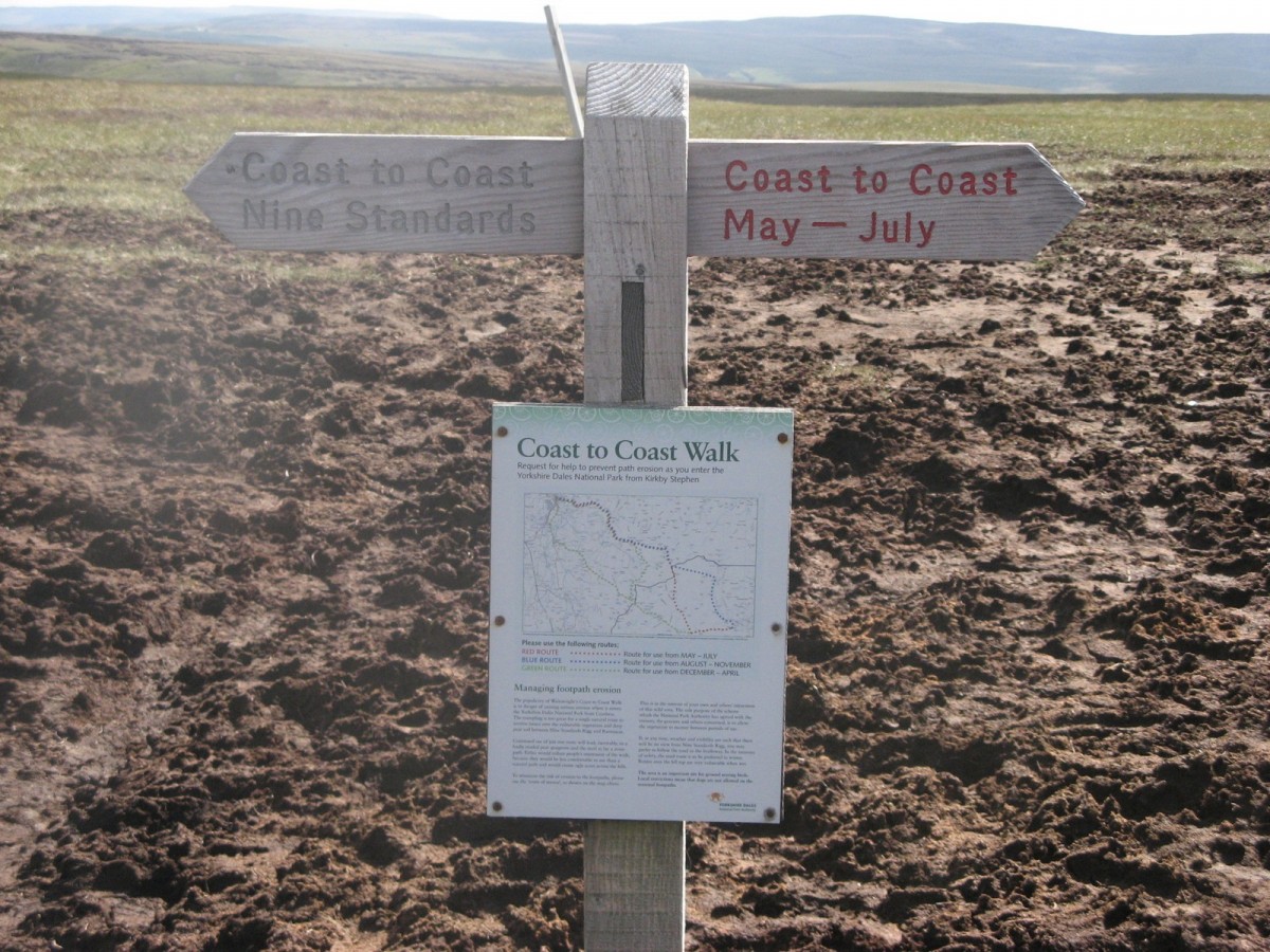
On to Keld. This section of the walk crosses the border from Cumbria into Yorkshire and the Pennine Hills, the watershed between the east and west of England. Watersheds mean bogs, treacherous bright green areas of plant life that will swallow you without trace. Wainwright offers various routes, but urges walkers to visit the Nine Standards Rigg, a curious set of cairns set high on Hartley Fell. Their origin is obscure, but the varied construction and the intricacy of the stone work are fascinating. The three different routes for this part of the trek are designated red, green and blue. This is their meeting point, politely described in the guidebook as mire. It is here that the watershed occurs; from now on rivers run to the east, towards the North Sea, rather than west into the Irish Sea.
Keld was my first experience of staying on a working farm, where the owners breed pedigree sheep. As always, lovely people and great food. A dry, cold, windy day greeted us as we set off the next morning to Richmond, the largest town en route, a walk across the moors and pastures, long but relatively comfortable. Accommodation in Richmond was at the Pottergate guesthouse, but sadly Dumbledore wasn’t in residence. A quick dinner of soup and toasties at the local pub hit the spot, and in the morning there was a choice at breakfast time that enabled me to take scrambled eggs on toast, despite the landlady urging a full English on me.
Richmond to Ingleby Cross was perhaps the least interesting day of the walk, with lots of fields full of wet grass and stinging nettles. The highlight was the White Lion at Danby Wiske, roughly the halfway point, a lovely pub that opened just as we arrived, the landlord explaining that “we keep an eye out for walkers”. Good English ale made up for the drab morning. We arrived at Ingleby Cross in the late afternoon. The accommodation here was one of the highlights of the walk, Park House B&B, set in the glorious countryside of Arncliffe Woods. Wonderful hospitality, with great hosts, Beverly and Mike.
It was here that the full English breakfast mercifully met its death. Beverly told me the story of offering a full English breakfast to a Coast to Coast walker shortly after she had taken over the business. Fixing her with a steely stare, the lady announced, “I never want to see another full English breakfast!” So fruit, yoghurt and a choice of excellent hot fare were on the menu, shared between an American, a Canadian, a Swiss, an Australian (me) and three Poms, a truly international gathering, all walking the Coast to Coast route.

From Ingleby Cross we picked up the Cleveland Way. This made life easier as the Way is very clearly signposted, and remarkably contains long stretches of paving. The effort involved in the construction of this track, high in the moors, is hard to imagine. Accommodation that night was at a farmhouse belonging to a great host, Dave Wray. Dave picked us up in the middle of nowhere, served us tea and cakes, took us to the Black Swan pub for dinner and the next morning produced your choice for breakfast, which meant anything from porridge to the good old full English and everything in between.
The following morning we set out for Glaisdale in a drizzle. Conditions gradually worsened until we were walking in heavy rain, driven into our faces by a strong wind. So much for walking west to east to keep the wind on your back, the vagaries of the English weather will prevail! Respite was gained at The Lion, a huge inn with two roaring log fires, filled with wet, steaming walkers of all nationalities. Suitably refreshed we pressed on, the weather improved and we reached our destination in the late afternoon, the Arncliffe arms in Glaisdale, after walking across the wonderfully named Great Fryup Moor—memories of breakfasts!
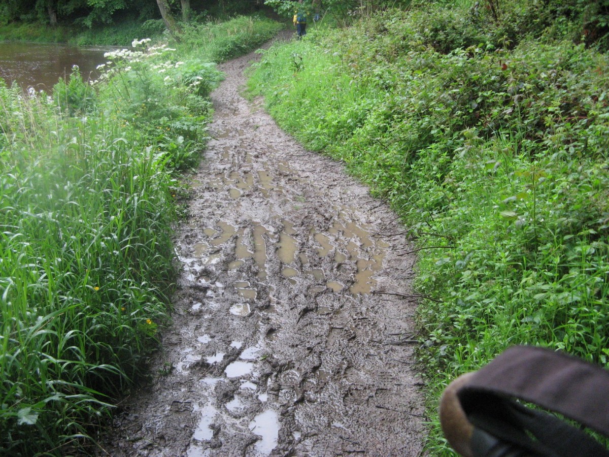
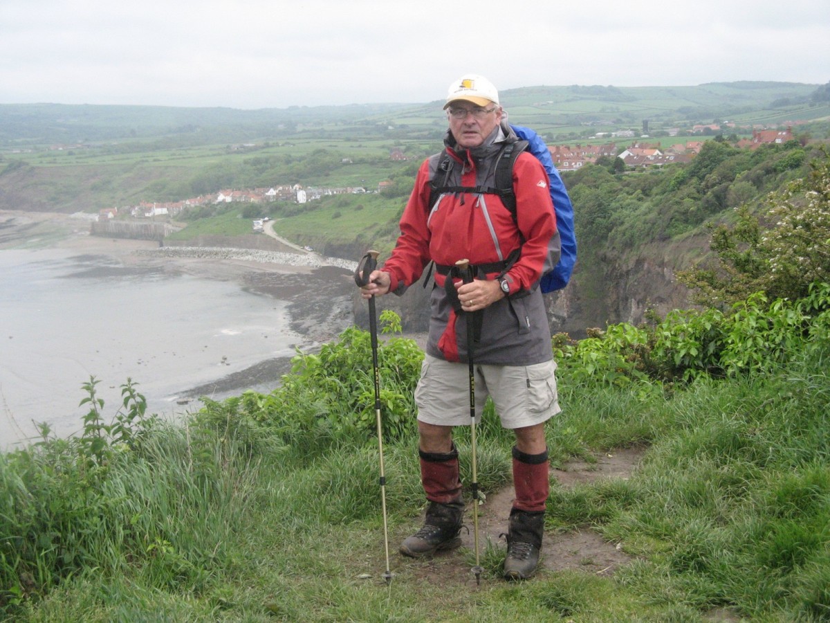
A good night’s rest was had by all and then our final day dawned. Unsurprisingly it was raining. We had seen a lot of mud, but the final day presented us with a mud extravaganza. We slid out of Glaisdale, and eventually slithered and sloshed our way to the half-way point, a twenty meter waterfall known as Falling Fosse, where an enterprising soul has set up a stall selling hot drinks and snacks, with tables sheltered by huge umbrellas. Fortified by mugs of steaming hot coffee we climbed the river bank, another long stretch of slippery mud, with the end of the journey in sight. However the final few miles were no stroll in the park, with two bogs to cross and a long walk around the headland. The first bog was treacherous, the second we had been advised would be worse, so we took a route around it. The walk along the cliff tops, although blustery, was dry underfoot and the small town of Robin Hood’s Bay soon appeared, way below.
All that remained now was to go down to the beach, dip our boots in the North Sea and drop our pebbles, lovingly carried from St. Bees. A surprising round of applause greeted us as we walked past the Bay Hotel, where several walkers that we had encountered in various places along the way were enjoying some al fresco refreshment. The Bay Hotel is home to Wainwright’s Bar, named after the great man himself. Here, walkers who have completed the route are invited to sign a special visitors’ book. From the beach it was a short stroll, back up to Wainwright’s Bar, for celebratory libations.
So the trip was over; eleven days covering 320 kilometres of some of Britain’s most beautiful countryside. Was it worthwhile? Yes, yes and yes! An account like this can only scratch the surface in describing the beauty of the surroundings and the camaraderie of fellow walkers. I’d like to say a special thank you to my Canadian friends, Ed and Lesley, with whom I walked most of the way and whose company was an absolute pleasure. For sure I would have got lost far more often without their guidance.
Would I change anything if I did it again? Not really. Having luggage transported ahead to accommodation meant there was nothing to think about each day other than the walk itself. In my case all the arrangements, including payment, were made on-line well in advance. I used a company in the UK called Northwestwalks (nww@northwestwalks.co.uk). Their service was excellent, with very good accommodation selections and my luggage always waiting for me at the end of the day.
My clothing was simple; hiking boots and socks, gaiters to keep out the mud and as protection from stinging nettles, shorts and a combination of a lightweight shirt, a merino thermal top and my Melaleuca rain jacket, depending on the conditions. Sending luggage ahead meant there was always a change of dry clothes the next day if I needed them.
As with any walk, preparation is essential. A good guide book and maps, a compass and possibly a GPS are required. Signposting is minimal and conditions sometimes can be dangerous. That apart, I would certainly recommend the Coast to Coast route as amongst the most interesting walks I have undertaken.
Next year? Offa’s Dyke looks interesting…
