A History of Guidebooks
There have been a number of Bibbulmun Track Guidebooks published over the years.
The first Guidebook titled “Guide to the Bibbulmun Bushwalking Track” was produced by the Forests Dept in August 1979. It was 111 pages (plus forward) covering the 27 Track Sections and was printed on paper that would allow erasure of the ink from ball point and felt pens. It included maps, limited Track notes, advice and the circuit and alternative routes. At this stage, the approx 500km Track began in Kalamunda and ended at the Boorara Tree south east of Northcliffe.

However in August, 1977, two years before the first Guidebook was released, a small extract was published by the Forests Dept titled “Collie Circuit Routes”.
_1200_802_50_c1.jpg)
In March 1985, CALM reprinted the first Guidebook in the same style but with an updated logo as well as reflecting the extension of the Track from the Boorara Tree to the old Shannon Townsite (adding an extra 23km to Section 27). This version retained the title “Guide to the Bibbulmun Bushwalking Track”.
_1200_806_50_c1.jpg)
The biggest change came after the Track was realigned between Kalamunda and Dwellingup and also extended to Walpole. At this point the Guidebook publish by CALM in 1988, retitled “A Guide to the Bibbulmun Track”, was 96 pages and the 27 “Sections” were replaced by 37 “Stages” for the 650km of Track. For the first time, profiles of ascents and descents were introduced on each map page but oddly the maps were no longer oriented with north to the top of the page. Track notes were replaced with brief descriptions and the maps contained less detail of the surrounds which arguable made them a little easier to read.
_1200_809_50_c1.jpg)
_220_480_50_c1.jpg)
With the Building a Better Bibbulmun Track project underway in the 1990s, the same Guidebook was issued with a new sticker on the cover and included a new map to cover the newly realigned section between Kalamunda and the Brookton Hwy in August 1997. The new map boasted detailed topography and on the reverse were detailed Track notes – a sign of what was to come with the next edition of maps and Guidebooks.
_1200_793_50_c1.jpg)
When the Track was completed to Albany in 1998, the previous Guidebooks were replaced with Northern and Southern volumes. The “A Guide to the Bibbulmun Track, Northern Half” (299 pages) was published by CALM in August 1998 before the Track opened in September 1998. The southern volume, “A Guide to the Bibbulmun Track, Southern Half” (315 pages) however was not available until November, 1998. The new volumes covered the new 58 Sections and together weighed over 500g. Both volumes included detailed topographic maps, section descriptions, detailed Track notes and for the first time, information on each shelter located at each campsite and the Friends of the Bibbulmun Track, now the Bibbulmun Track Foundation. The second editions of these volumes were published by CALM in April 2002 (Northern volume, 301 pages) and November 2004 (southern volume, 325 pages).

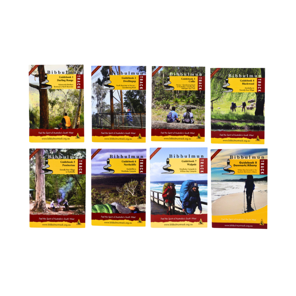
In 2014, the Bibbulmun Track Foundation published the latest style of Guidebooks. At this point the two volumes were split into nine separate lightweight books. The first one being the Bibbulmun Track Handbook which covers topics like natural and human history, geography and advice – most of the information many walkers would not wish to carry on their walk. The remaining eight volumes, the Guidebooks, match the eight official Bibbulmun Track maps (published by DBCA) with respect to the section of the Track they cover. The Track notes were completely re-written for these editions but no longer contain the maps and profiles as this data belongs to the Dept. The latest Guidebooks are kept up to date and those who have purchased them will find a weblink on page 3 of each volume to access ongoing updates. The second editions of each volume are now available and weigh around 80g each. (see image below)