Pemberton
The walk from Pemberton to Northcliffe is well known for pleasant walking through the karri forest. A shorter walk between these towns (three days, two nights), it is the perfect section for a quick getaway. It boasts the famous Gloucester Tree which is well worth a climb – but take off your pack before you climb the 61 metres to the top. The Warren campsite is nestled in the karri forest whilst Schafer campsite. named after Geoff Schafer, is on the banks of a welcome swimming hole.
Pemberton
Pemberton is situated in a valley, surrounded by the karri forests of the Gloucester National Park and the Pemberton Forest Park. It is a pretty timber town, which enjoys a cool climate and has a good variety of attractions, so it’s worth planning to stay an extra day or two.
More InformationNorthcliffe
Located 360km south of Perth, Northcliffe has the unique distinction of being the only town founded in WA specifically for the First World War Group Settlement Scheme. There is an old fashioned country, community spirit that is still alive in Northcliffe, which has existed since the early settlement days.
More InformationMuirillup Rd
Middleton Rd
Lane-Poole Rd
Karri Hill Rd
Hill Brook Rd
Wheatley Coast Rd
River Rd Bridge
Gloucester Rd
Cascades Spur Trail
Gloucester Tree
Schafer Campsite
Capacity: 12-15 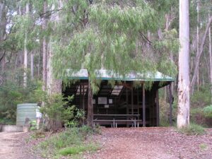
Warren Campsite
Capacity: 12-15 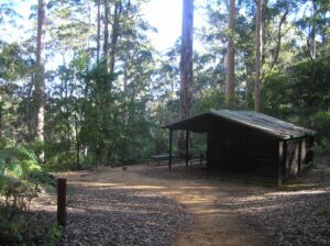
Pemberton Visitor Centre
Pemberton Visitor Centre
Distance to track: On the Track
Distance to nearest town: In town
Tel: (08) 9776 1133
61 Brockman Street
Pemberton 6260
Pemberton Discovery Tours
Distance to track: On the Track
Distance to nearest town: In town
Nearest town: Pemberton
Tel: (08) 9776 0484
12 Brockman Street
Pemberton 6260
Pemberton Discovery Tours
Distance to track: On the Track
Distance to nearest town: In town
Nearest town: Pemberton
Tel: (08) 9776 0484
12 Brockman Street
Pemberton 6260
Pemberton Discovery Tours
Distance to track: On the Track
Distance to nearest town: In town
Nearest town: Pemberton
Tel: (08) 9776 0484
12 Brockman Street
Pemberton 6260
Pemberton Discovery Tours
Distance to track: On the Track
Distance to nearest town: In town
Nearest town: Pemberton
Tel: (08) 9776 0484
12 Brockman Street
Pemberton 6260
Pemberton Discovery Tours
Distance to track: On the Track
Distance to nearest town: In town
Nearest town: Pemberton
Tel: (08) 9776 0484
12 Brockman Street
Pemberton 6260
Pemberton Discovery Tours
Distance to track: On the Track
Distance to nearest town: In town
Nearest town: Pemberton
Tel: (08) 9776 0484
12 Brockman Street
Pemberton 6260
Forest Lodge Resort
Distance to track: 1.4km
Distance to nearest town: 1.4km
Nearest town: Pemberton
Tel: (08) 9776 1113
Mob: 0478 654 170
13626 Vasse Highway
Pemberton 6260
Treenbrook Cottages
Distance to track: 7.1km from Cascades access, 14.8 km from Beedalup Fall access
Distance to nearest town: 5.2km from the town of Pemberton, WA
Nearest town: Pemberton
Tel: 08 9776 1638
Mob: 0427761638
12928 Vasse Hwy, Yeagarup, 6260
Yeagarup 6260
Willow on Pine
Distance to track: 1.5km
Distance to nearest town: 0.3km
Nearest town: Pemberton
Mob: 0430479297
6 Pine Street
Pemberton 6260
Pemberton Hotel
Distance to track: Less than a kilometer
Distance to nearest town: 0km
Nearest town: Pemberton
Tel: 0897761017
70 - 78 Brockman Street
Pemberton, WA 6260
Pemberton Hotel
Distance to track: Less than a kilometer
Distance to nearest town: 0km
Nearest town: Pemberton
Tel: 0897761017
70 - 78 Brockman Street
Pemberton, WA 6260