From this deep reverence for nature, the Aborigines lived in harmony with the land and its creatures.
When you walk in the forest of the mighty karri and the first rain drifts slowly down through the canopy, stand still and close your eyes. Turn your face upwards and feel the coolness on your skin. From far, far away, you will hear the chanting begin.
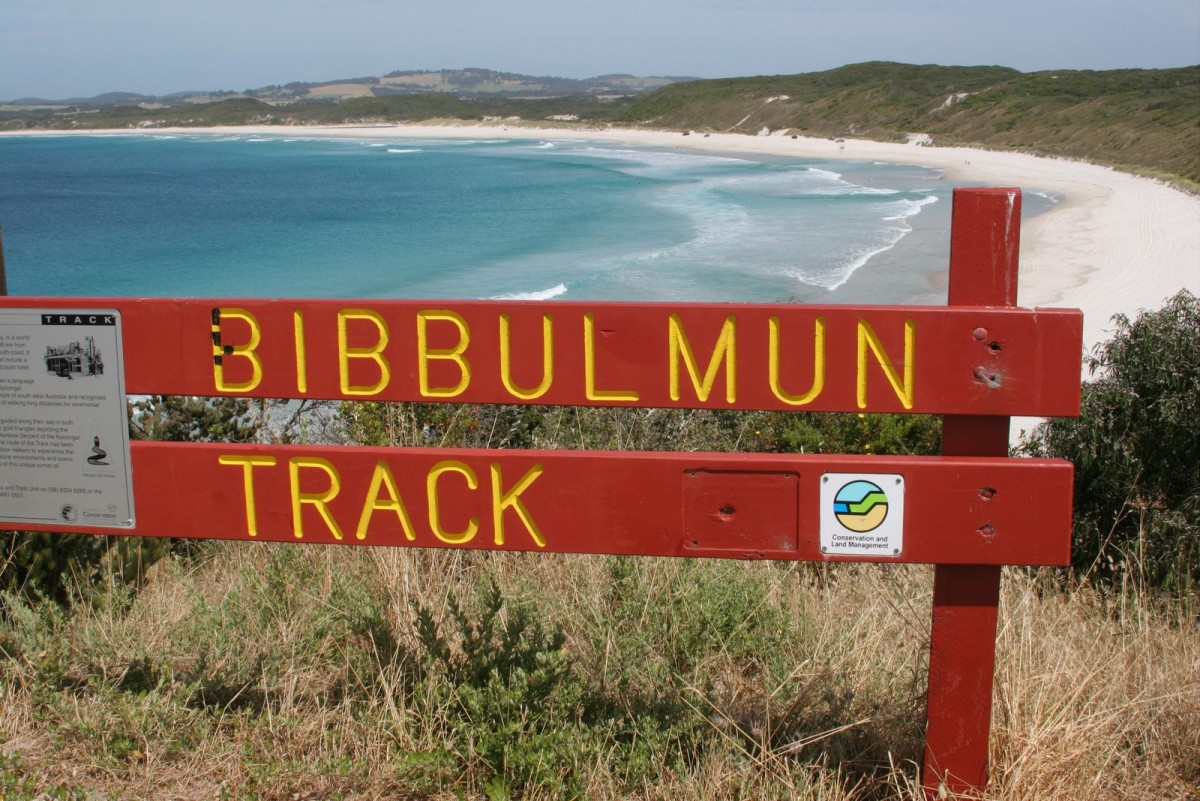
When a name was being sought for a proposed long distance track in the south-west many options were considered. It was Kirup forester Len Talbot who proposed that the Track be named to recognise the early indigenous inhabitants of the southwest, the Bibbulmun. It was known that the Bibbulmun people walked long distances through the forests for ceremonial gatherings, and although those precise travel routes were unknown, the name was adopted as being unique and appropriate for a trail on which it was hoped walkers would adopt the same feeling of oneness with nature of those people of long ago.
Bushwalking was a recreational pursuit in WA before the Second World War, the Western Walking Club having been founded in 1937. In 1969 the Perth Bushwalking Club came into being, and founding member Geoff Schafer was less than impressed by the facilities that the State offered for walkers in terms of long distance walks. Geoff was a veteran of the 650km walk through the Victorian Alps, and he was dismayed that WA had no comparable track. In July 1972 he walked into the office of the then Minister for Forests, H.D. Evans, with an idea designed to prompt urban people to go bush. The Minister listened, liked what he heard, and sent Geoff and his idea to the Forests Department with a green light to go ahead with his proposed Perth to Albany walk track.
The proposal caused consternation in the Forests Department, which at the time had only a very small recreation budget, and little or no knowledge of long distance trails. Fortunately there were officers who seized on the inspiration Geoff's idea provided, and set about the considerable challenge it posed. Foremost among these were Peter Hewett, Wayne Schmidt and Ross Gobby.
By September of 1972 the enthusiastic planning team had designed on paper a Lancelin-to-Albany walk, via the Leeuwin-Naturaliste ridge, but in ensuing months it was realised this was unrealistic, and this proposition was abandoned in favour of a shorter Kalamunda to Northcliffe proposal. It was at this time that the name Bibbulmun Track was adopted and the first alignment of the Track was marked on the ground in March 1974.
_and_Geoff_Schaferin_2008.jpg)
In October 1979, the Bibbulmun Track was officially opened as part of Western Australia's 150th year celebrations, an event celebrated by Bibbulmun Walk '79. This 900km journey (which strangely began in Albany, although officially the Track went only from Kalamunda to Northcliffe), included a full traverse of the Track, and involved over 1000 walkers on different stages. Media coverage of the Bibbulmun Walk was extensive, and community response all along the route reflected a growing acceptance of the Track as a significant means of recreational access to the forests of the southwest. Numerous schools took part in the walk, as did most local Shire Councils, with the Kalamunda Shire playing a leading role in organising and promoting the whole venture. A core group of hardy souls walked the whole distance, thus becoming perhaps the first official end-to-enders.
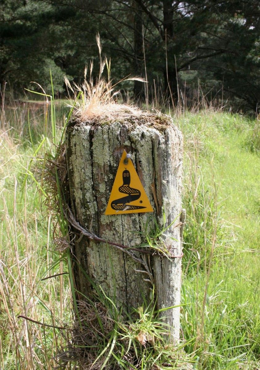
During 1987/88 the then newly formed Department of Conservation and Land Management (CALM) undertook a significant overhaul of the Track, including relocation of the section between Kalamunda and Dwellingup to avoid conflict with bauxite mining, and extending the Track further south from Northcliffe to Walpole. This project, overseen by Project Officer Drew Griffiths, saw the incorporation of the Track into the State's Heritage Trail network, and the adoption of the distinctive Waugal symbol as a trail marker. The mythology of the Aboriginal people throughout Australia is dominated by stories of the Rainbow Serpent, seen as the creator of the universe and its people. The serpent is known by the Bibbulmun people as the Waugal, meaning soul, spirit or breath. The use of a depiction of the Waugal as a trail marker was considered wholly appropriate for a Track named in recognition of the indigenous people of the region. The markers depict a black serpent on a fluorescent yellow background, and walkers should follow the direction of the serpent’s head.
By the early nineties walkers and CALM staff were once again reporting a range of issues impacting on the Track, mainly focused around ongoing conflict with other land uses; forestry operations, mining, water catchment, vehicles and a range of roads of various sizes, and it was at this moment another visionary, following in the footsteps of Geoff Schafer, arrived on the scene.
Jesse Brampton was brought up on a sheep farm south east of Perth. In April 1987 he decided to walk the Appalachian Trail in the USA, which stretches 3434 km from Maine in the north to Georgia in the south. Jesse walked its full length between May 1987 and September 1988. A year later, after his return to Australia, Jesse walked the Bibbulmun Track and was shocked by the comparison. The Bibbulmun Track at that time followed mostly gravel roads rather than paths through the bush, there was inadequate signage, no shelters along the way, few toilet facilities and no guaranteed supply of water—little to attract the inexperienced or family hiker. The Appalachian Trail by comparison had wooden shelters along its full length, adequate water supplies and volunteers maintaining the trail—and it offered walkers deep immersion in beautiful natural landscapes along most of its length.
Following Jesse’s advice, the model chosen for the new Track was the Appalachian Trail and close connections were made at the Appalachian Trail Conference. The first requirement of the planning stage was to determine the physical alignment of the new Track. The goals that the team set themselves were to minimise conflicts of interest, to maximise the quality of the walkers’ experiences on the Track, and to offer a safe experience to as broad a range of people as possible.

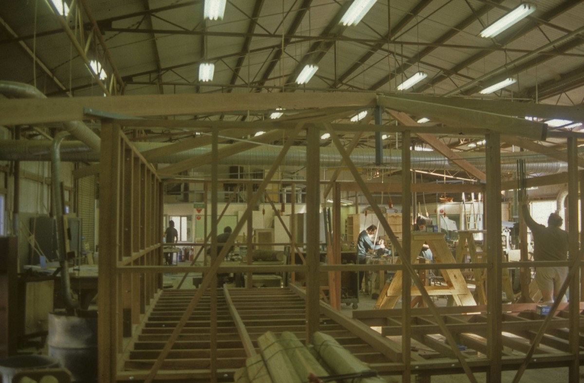
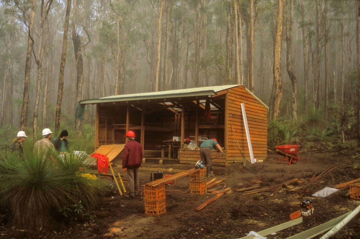
Then came a development that gave the project a huge boost. Bob Dixon, then the Manager of Prison Industries, together with Denzell McCotter, the Director for Prison Operations had become aware of the Bibbulmun Track Project and the need for assistance in the construction of the new Track. Their initial interest was in using prison inmates to prefabricate shelters and toilet facilities in prison workshops. Agreement was reached to not only offer construction but also to allow minimum security prisoners from Wooroloo Prison Farm, 60km east of Perth, to assist with erecting the facilities on site and in the construction of the Track.
This was just the kick-start that the project needed to get construction underway. The first Ministry of Justice shelter and campsite project took nine weeks. For the first two, the prisoners shuffled around, heads down, uneasy and shy. By the end, they were at ease, taking pride in their work and offering suggestions for improvement of the facilities. The first campsite was named Waalegh and opened by WA Premier Richard Court in August 1994. In the following year, 1995, the first 68km of the Track were completed and a further three campsites constructed, all using prison labour and the budget of the Ministry of Justice.
It is worth looking at the contribution of the Ministry of Justice and the prisoners themselves in a little more detail, as well as the more far-ranging benefits of the relationship forged between the Ministry and CALM. Not only do the prisoners themselves deserve mention, but also those officials in the then Ministry of Justice (now the Corrective Services Department), for their vision and courage in promoting the schemes that allowed the work to be done. Not many walkers perhaps realise some of the wooden shelters they reach thankfully at the end of the day were prefabricated in prison workshops and erected by prisoners, or that the steps in the hills that make their trek easier were carved out by the hands of those same men.
Following the work done by the prisoners from Wooroloo in 1994 and 1995, crews from Karnet Prison Farm, 80km south of Perth, and Pardelup Prison Farm, 330km southwest of Perth, commenced work on the Track. Crews of eight prisoners and one prison officer set out each day to work on the Track and return to the prison at night. Prisoners who were allowed to work on the project were carefully chosen for their suitability to join a work crew.
Despite the fact that the work was physically demanding, to be a member of a work crew on the Bibbulmun Track became a much sought-after privilege and the efforts of individual prisoners were recognised in various ways. The growth of the self esteem of these men and the pride they took in creating the Track became very clear, and a strong rapport grew up between the prisoners, the officers and the CALM supervisors. By the end of 1998 the benefits to both CALM and the Ministry of Justice were becoming obvious and high level talks were held between the two agencies regarding the use of prison labour for further projects.
As a result of these talks a memorandum of understanding was set up between the two agencies and the first prison work camp was set up at Walpole, followed shortly after by a second at Badgingarra, 200km north of Perth. Initially the prisoners stayed at the camp from Monday through Thursday night and returned to the prison on Friday afternoon; however since the beginning of 1999 the crews have been allowed to stay full time at the camps.
In 1998 the Premier’s Award for Public Sector management was made jointly to CALM and the Ministry of Justice for their combined efforts on the Bibbulmun Track and at that time it was noted that the contribution in-kind of the Ministry to the project exceeded $1.5 million.
The vision for the new Track attracted a wide variety of other groups to volunteer for campsite construction tasks. The Collie Combined Service Clubs undertook four weekend busy bees, building the Yourdamung and Harris Dam campsites north of Collie, the Noggerup campsite south of the Preston River, and the bridge over the Harris River. Inspired by these feats, staff from Worsley Alumina volunteered for similar construction weekends, completing both the Possum Springs and Dookanelly campsites, sponsored by the company. Many other groups have made similar contributions, surrendering weekends to the shared goal of building the new Bibbulmun Track. A range of Department of Employment, Education and Training job skills programs undertook trail, boardwalk and campsite construction work on the Track.
At all times the CALM Districts along the Track were active in the field, and in August 1995 the first section of the new Track, from Kalamunda to the Brookton Highway, was officially opened, and a new map of the section incorporating Track notes was produced.
Funding was still a matter of on-going concern. At this time there was no substantial Government financial support and funding consisted of small to moderate commitments from various community and corporate sources. The lack of a major allocation of funds restricted clear forward planning. Goals therefore were reset for completion of the northern half by late 1996 and the southern half by late 1997, depending on the availability of resources. Construction work continued, with a steady increase in the number of individual sponsors.
Circumstances changed dramatically on February 10th, 1996, when it was announced that the Project Team had been successful in winning a grant from the Federal Department of Housing and Regional Development (RDO). The grant was worth $1.38 million dollars over a two year period, and included a contractual obligation to complete the Track by May 1st 1998. This influx of funds allowed employment of some full-time support and enabled the pace of construction to speed up considerably over the next twelve months. In February 1997 the Project Team announced firm dates for the opening of the whole redeveloped Track as August 15th 1997 for the northern section and August 15th 1998 for the southern section.
The northern section was formally opened by the WA Premier Richard Court on August 14th, 1997. This new northern section of the Track was 453km in length and featured 26 upgraded campsites. It connected with the old southern section at Karri Gully on the Brockman Highway.
In 1997 the Friends of the Bibbulmun Track came into being, a not-for-profit organisation that would support CALM in the management, maintenance and marketing of the Track. This organisation is now known as the Bibbulmun Track Foundation, and for information about the history of the Foundation see About the Foundation and How it all got started.
Work continued apace on the southern section, including the extension of the Track from Walpole to Albany. Further funding was obtained under the Federal Government’s Green Corps environmental traineeship scheme for construction work in the West Cape Howe National Park.
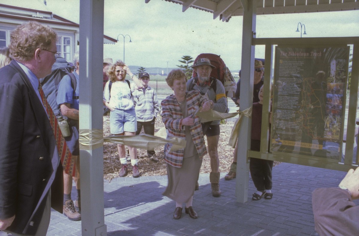
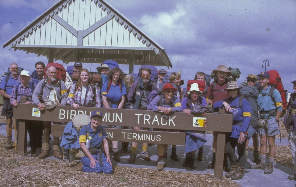
Finally the southern section was completed, and the great day arrived, with the Hon. Cheryl Edwards, the Minister for the Environment, opening the whole Track on September 13th 1998.
Since that historic moment, when the Track was officially opened, the co-operation between the now Department Parks and Wildlife and the Department of Corrective Services has continued uninterrupted
The next time you set foot on the Bibbulmun Track, pause and give a few moments thought to all those who have made your walk possible, the visionaries, the planners, and those who performed the physical construction, including the prison crews, past and present.
So the dream had become a reality, and an end-to-end walk was organized to celebrate the opening. Ten walkers completed the whole journey, which commenced on September 13th and was led by Bonnie Hennessey, who is still very actively involved with the Bibbulmun Track Foundation. They were joined at various points along the way by many other walkers who walked sections of the Track with them. The event was coordinated by Becky Shrimpton, who later became the Foundation’s Executive Director and Annie Keating of CALM. It generated wide community awareness of not only the Bibbulmun Track but also the existence of recreational trails in general. I quote from Bonnie Hennessey’s comments in the 1998 Walk Diary:
“The loving concern shown by one human being to another is my most vivid memory of this walk. Sharing physical things, food, clothing, first-aid gear, insect repellent, also laughter, ideas, help with backpacks, joy in the flowers and birds. The courage of some, the growth of others, the watchfulness of most, the list is endless. Would that the whole world could find peace as we found it during those eight weeks.”
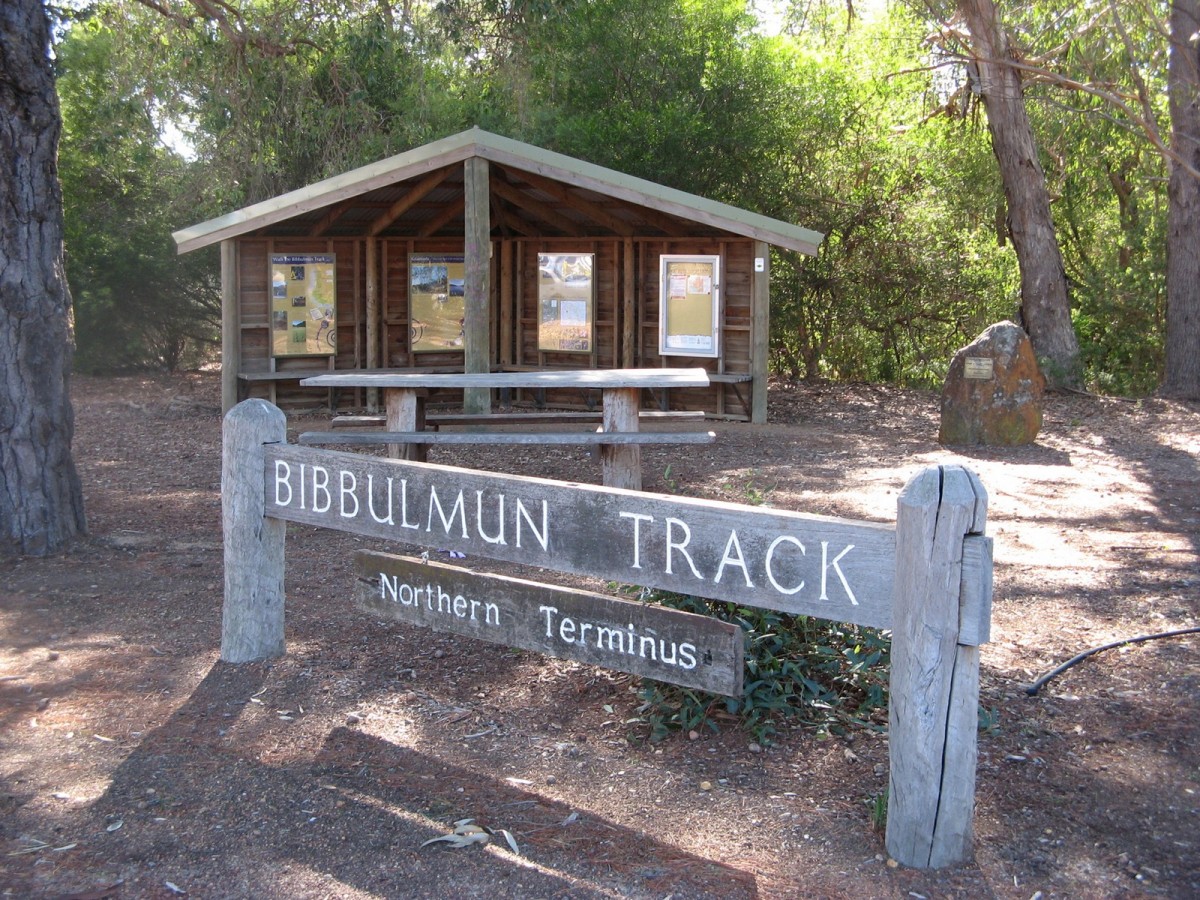
CALM is now known as the Parks and Wildlife Service at the Department of Biodiversity, Conservation and Attractions and continues to manage the Track, supported by the Bibbulmun Track Foundation (BTF). The use of the Track has grown exponentially over the past fifteen years, which has meant an enormous increase in demand upon the staff and volunteers. People come to WA from all over the world to walk on the Track. It stretches almost 1000km through a wide variety of jarrah, marri, wandoo, karri and tingle forests, interspersed with sections of coastal peppermint and heathlands. It traverses some of the most beautiful and wild areas of the south west, and offers facilities unrivalled on any long distance trail in Australia. Most importantly, it thoroughly and without question fulfils Geoff Schafer and Jesse Brampton's dreams of a long-distance walk track designed to prompt people of all ages and experience levels to go bush.
Some realignment of the Track has been necessary, and refurbishment programs have ensured the infrastructure that makes the Track such a walker friendly experience has been kept in good condition.
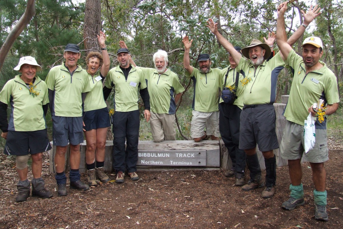
In 2008 it was decided to mark the tenth anniversary of the opening of the Track by repeating the end-to-end walk of 1998, and the walkers started from Albany on July 16th, led by Steve Sertis, the BTF Events Manager and Lead Guide, and Mike Wood, Chairman of the BTF. Nine walkers completed the 1000km in eight weeks and were joined along the route by many sectional walkers. The walk was an important way to re-energise people’s passion for the Track particularly in the regional towns where hundreds of school children and other locals joined the walkers for parades and celebrations in each town.
Nowadays, the Foundation organises some sixty to seventy events on the Track every year designed to appeal to people of all ages and levels of fitness, ranging from walks for parents with their kids to eight and nine day fully inclusive tours.
The Bibbulmun Track is a living entity and as such requires care and attention to maintain its integrity and attractiveness---may it last for many, many years to come!
For information about how the Foundation got started see About the Foundation and How it all got started.


