Jeju Olle Trail, South Korea
Jeju is a volcanic island located off the southern tip of South Korea. Its sub-tropical climate has always made it a popular venue for Koreans, especially honeymooners, over decades. It is a place of great beauty, with picturesque lava rock scenery, ocean cliff views and beautiful groves of tangerine trees. Located in the centre is the dormant volcano Mt. Hallasan.
Recently, large numbers of international tourists have visited Jeju, many of whom have been attracted by the Jeju Olle Trail. Established in 2007 by the Jeju Olle Foundation, the Jeju Olle Trail spans over 400 kilometres of beautifully maintained and managed walking trails. Olle translates as a narrow pathway that connects the street to the front gate of one’s house.
The Jeju Olle Trail consists of more than twenty individual interconnected tracks on Jeju itself, ranging from five to 23 kilometres in length, with other trails on nearby smaller islands.
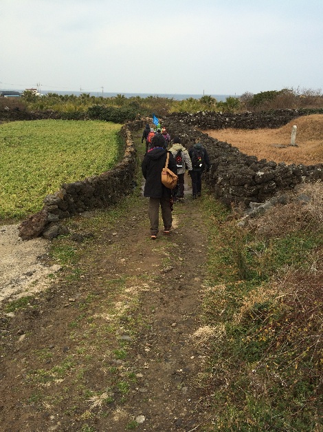
Routes range from a casual stroll on wooden planks on level surfaces to tougher climbs up the island’s volcano cones. The trails pass through various landscapes along the way including small villages, beaches, farms and forests. Each specific route is an opportunity to soak in the beauty of Jeju and the island’s culture.
The majority of the trails are based on old footpath routes between and around neighbouring villages. All the paths are clearly marked; blue and orange arrows guide the walker (blue pointing the clockwise direction and orange pointing the counter clockwise way), ribbons hang from tree branches, and spray painted arrows in blue help to show the way.
The most famous route marker, however, is the Ganse pony. The Ganse pony is the symbol of the trail and the Jeju Olle Foundation, and represents the small ponies that used to roam the island. The name comes from an old Jeju dialect meaning slow, lazybones, hence, the spirit of walking slowly on the trail. These markers are prevalent at major stops along the trail routes and mark how many kilometres the user has walked of each specific route.
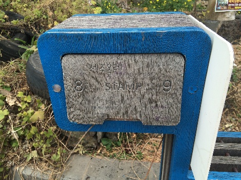
Trail users can show their love of the trail by taking part in the passport program. Each route has two or three unique stamps that can be placed in a passport booklet once that section of the trail is completed. Hikers can collect the stamps to display the length of the trail they have accomplished. The passport program is a great way to capture the enthusiasm of children hiking along the trail with their parents; a goal that the Jeju Olle Trail and Foundation are working towards.
As with the Bibbulmun Track, walkers can decide on how much or how little of the walk they wish to undertake. Each section of the Jeju Olle Trail has toilet facilities and shops at the beginning and end and there are many restaurants and street stalls along the way, so local provisions and water are readily available.

A good resource for choosing the right trail is the official Olle website (www.jejuolle.org). All the trails have been carefully designed and they each have a unique flavour. You don’t have to be incredibly fit to walk an Olle trail, but they can be tiring. The only real dangers are falling rocks (look up), falling off a rock (don’t look down), or storms; the island is prone to heavy winds and typhoons so check the weather before you set off.
Wherever you go, on Jeju you’re rarely far from a bus or a taxi. Most of the trails are near a bus stop of some kind, or pass through towns.
The Jeju people have fully embraced the Jeju Olle Trail by providing housing along the routes for hikers travelling for the long-term. Many guesthouses, where hikers can rent a room for the night, and grandmother houses, where users can rent for longer extended periods of time, are frequent along the trail and make planning a long hiking expedition easier.
Hospitality and generosity are attributes the Jeju people take pride in, and this makes for an enjoyable hiking experience. Many sections of the trail routes cross private land; including walking through farmer’s fields of carrots, lettuce, and turnips, or an occasional cow or sheep pasture. The connection of the user to the land is enhanced by this aspect of scenery, and provides for a cultural experience as well. Grave markers of ancestors also line the trail surrounded by lava rock walls giving the hiker an insight into traditional Jeju life. When a relative passes away, they are buried in their favourite spot on the island, so it is not a surprise that the trail passes by so many of these markers.
Fact File
When to go: Jeju is subtropical but can be very cold in the winter and hot and humid in the summer. So aim for either March to May or September to November.
What to wear: Good walking footwear, lightweight clothing, rain jacket, lightweight fleece.
Equipment: Day-pack, water bottle, basic first aid kit.
Guidebook: Available free of charge at the Jeju International Airport
Food: Be prepared to not find much western style food along the way. Carry some snacks!
Water: Generally OK and safe but take water treatment tablets if you have any qualms about the local water source.
How to get there: Fly to Seoul and then on to Jeju on a Korean domestic flight. Alternatively if you want to see more of the country there are ferries from a number of towns in the south of Korea that you can take across to the island. Go to the Visit Korea website.
The Jeju Olle is a Bibbulmun Track Friendship Trail