Denmark/Albany
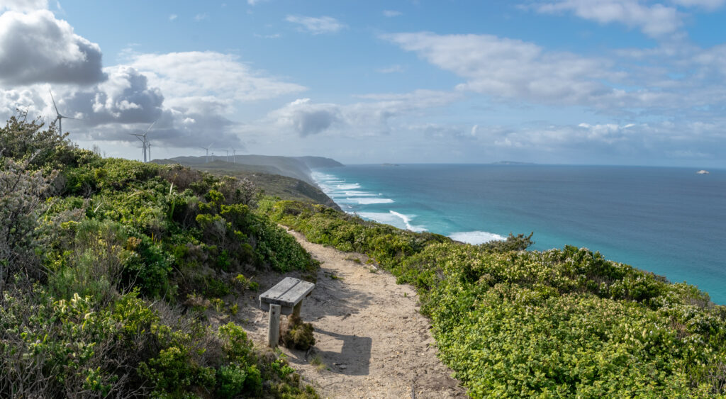
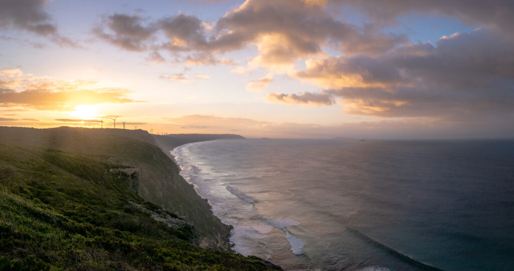
Denmark to Albany is an easier coastal section to walk than Peaceful Bay to Denmark. Walkers will need to plan ahead before crossing the Wilson and Torbay Inlets. This section offers sheltered swimming spots and some of the best uninterrupted scenery along the south coast. Views of the windfarm from the West Cape Howe National Park are a signal to southbound walkers that they are approaching the southern terminus and the end of their walk in Albany.
The Wilson Inlet, named by Governor Stirling after Thomas Braidwood Wilson, has an area of about 48 square kilometres. Walkers here face the question of how to cross the water separating the town from the Nullaki Peninsula. A seasonal sandbar forms at the mouth of the inlet, which means that for part of the year the inlet is isolated from the sea. There are options to cross the inlet. Read more about these options in the Section by Section guide.

Once on the east side of Denmark, the Track wends it way through low, dense paperbark thickets. Waterbirds are in abundance and include large flocks of black swans, pelicans, ducks, cormorants, egrets and many migratory waders.
Entering the West Cape Howe National Park, which was subjected to a severe wildfire in 2001, walkers find themselves close to the southernmost point of Western Australia, Torbay Head. Beyond the cape lies the settlement of Torbay as well as the small settlements of Kronkup, Elleker and Grasmere. At one time these settlements were linked by a rail line from Denmark to Albany. The views of the Southern Ocean from the cliff top are awe inspiring, and at certain times of the year whales and dolphins may be spotted in the waters below.
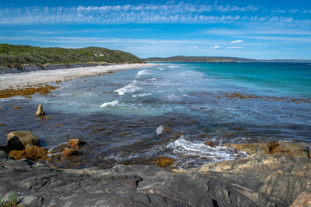
The final stages of the Track include quite a lot of walking along the beautiful pristine beaches of the south coast. Beautiful – but hard work, especially if the wind is strong and in your face! And there is another inlet to cross shortly after leaving the Torbay campsite.
The Torbay Inlet channel is rarely more than ankle deep, but it can be well over one meter deep during peak flows. For many months of the year, it is easily traversed, as a sandbar blocks the channel. When the channel is open, usually during winter and spring months, the crossing can be waded using extreme caution. If the water appears to be flowing swiftly upstream, walk across at the sea end of the inlet. This is usually fairly shallow. For safety information and alternative routes read the Section by Section guide.

Walkers heading east through the West Cape Howe National Park are soon able to see the tremendous turbines of the Albany wind farm. The wind farm is in an elevated position approximately 80m above the Southern Ocean. This height, proximity to the coastline and small distance to the electricity grid in Albany make this an exceptional wind farm site producing around 80% of Albany’s electricity needs with clean, inexhaustible renewable energy.
The view from the lookout platform at the Mutton Bird car park (28.5km west of Albany) provides ample reward for effort expended in circling the bay for walkers coming west.
Before reaching Sandpatch, the Bibbulmun Track features spectacular scenery as it wends its way between the wind farm and the coastal cliffs. Here, much of the Track follows boardwalks for long stretches to protect the cliff tops from erosion.
The Albany coastline, long ago attached to Antarctica, displays some of the oldest rocks in the world. Torndirrup National Park and Princess Royal Harbour offer spectacular scenery, such as the Gap and the Natural Bridge. The views of Albany for southbound walkers become more frequent as the trail descends from the coastal dunes, to the point where it crosses Frenchman Bay Road and joins the dual-use pathway around the foreshore. From here, the Track winds a circuitous but attractive route into town, and ends at the Southern Terminus alongside the visitor centre on York St, the city’s main street.
In days gone by, the last few hundred meters of the Track took walkers past the replica of the brig Amity, which brought a British Army expedition from Sydney, arriving on Christmas Day in 1826, when a military base was founded on the site. Some 60 people made the trip from Sydney in the tiny ship with sheep, pigs, cattle, plants, seeds and stores. The Amity can still be seen near the waterfront.

The Amity was built in Canada in 1816. It arrived in Sydney in 1824 and was used in the colonial service. In 1831 it was sold back into private ownership and operated in Tasmania until in June 1845 it was wrecked in the Bass Strait on an uncharted sandbank.
In 1975 craftsmen using timber from local forests began building the Amity replica, which was finished and officially opened to the public in 1977.
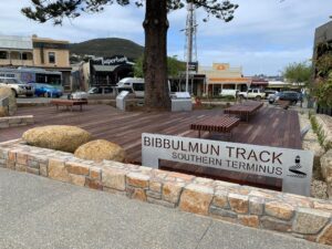
The recently relocated Southern Terminus in Albany
The Southern Terminus of the Bibbulmun Track is now located in the centre of town next to the Albany visitors centre.
For more information on walking from Denmark to Albany go to the Section by Section Guide.