Sally Woodhead, Perth, WA
The Tongariro National Park is the oldest National Park in New Zealand, located close to the centre of the North Island, to the south-west of Lake Taupa. If you are lucky enough to be blessed with a clear sky on your arrival at the Park, you will have a wonderful view of its three famous volcanoes; Mount Ruapehu, Mount Ngauruhoe and Mount Tongariro. The Tongariro Northern Circuit is an amazing hike, or “tramp, as New Zealanders call it. It is labeled one of New Zealand’s Great Walks, and includes the famous Tongariro Crossing, which is regarded as possibly the best one-day walk in the whole country.

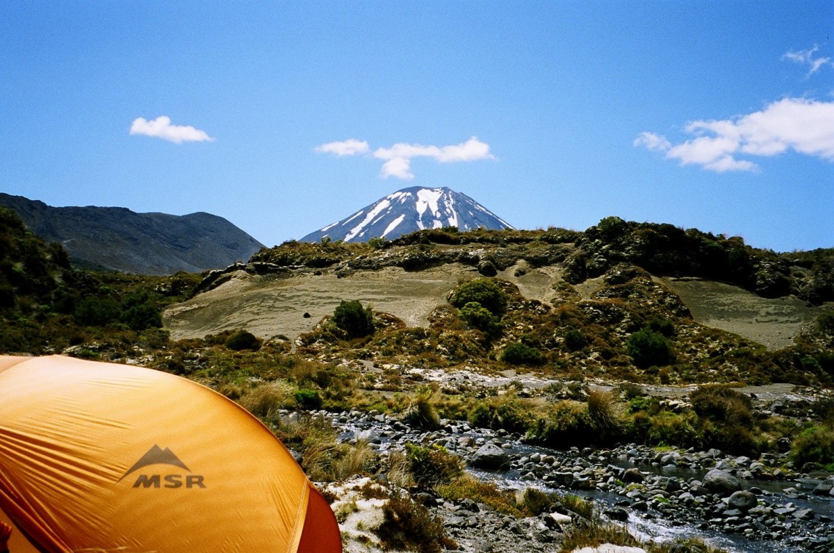
The Circuit begins at the foot of Mount Ruapehu, an active volcano which erupted as recently as September 2007. It then makes a loop around the beautifully symmetrical Mount Ngauruhoe (Mount Doom in the film version of Tolkien’s Lord of the Rings), crosses Mount Tongariro and returns to the foot of Mount Ruapehu.
In December last year we flew from Perth to Auckland, from where we took the Overlander Train to the National Park township, a journey of five hours. The township is the gateway to the Tongariro National Park, located about nine kilometers from the Park itself. From there we were taken by shuttle van to Whakapapa Village, the hub from which all outdoor activities in the Park commence. We stayed in the village for two nights to recover from our eighteen hour journey from Perth. The Whakapapa Visitor Centre is the point at which registration and payment for the walk is made, and your itinerary can be noted for safety purposes.
The track is served by four huts: Mangatepopo, Ketetahi, Oturere and Waihohonu. A small fee is payable for either hut bookings or camping. However if you elect to use your tent and camp (our preference) you may still use the huts for cooking, drying off and getting warm, but not for sleeping. And so, suitably refreshed, we set off.
The first day’s walk was 8.5km from Whakapapa Village to Mangatepopo Hut. We started on a very well maintained trail, which deteriorated into a series of narrow creeks with plenty of mud and water. The sun was shining in the early morning and promised a lovely day, but it didn’t last and we ended up in rain and hail. However at the end of the day we had a warm toasty hut in which to dry off. The weather forecast had been for hail and snow in the high ground, and it was correct. That night our tent was frozen over and there was snow on the ground just 200meters above us.
On day two we tackled the 13.5km from Mangatepopo Hut to Ketetahi Hut. This part of the tramp includes the Tongariro Crossing, the highest point of which is 1886m. After a snowy night we were lucky enough to be able to see snow covered mountains on a clear, sunny day. The weather was perfect for the crossing and for viewing the amazing colored lakes. The air was full of the smell of sulphur, which was puffing out from the sides of the craters. It was a very tough, rewarding day. Walkers should be aware that that the crossing can be precarious and can only be completed if the weather permits.
There is an option on this section to summit Mt Ngauruhoe—an additional three hour walk, which we were unable to do because of the fresh snow fall. With crampons and an ice axe it would have been feasible.
The views from the Ketatahi Hut are magnificent, overlooking Lake Rotoaira and, in the distance, Lake Taupo.

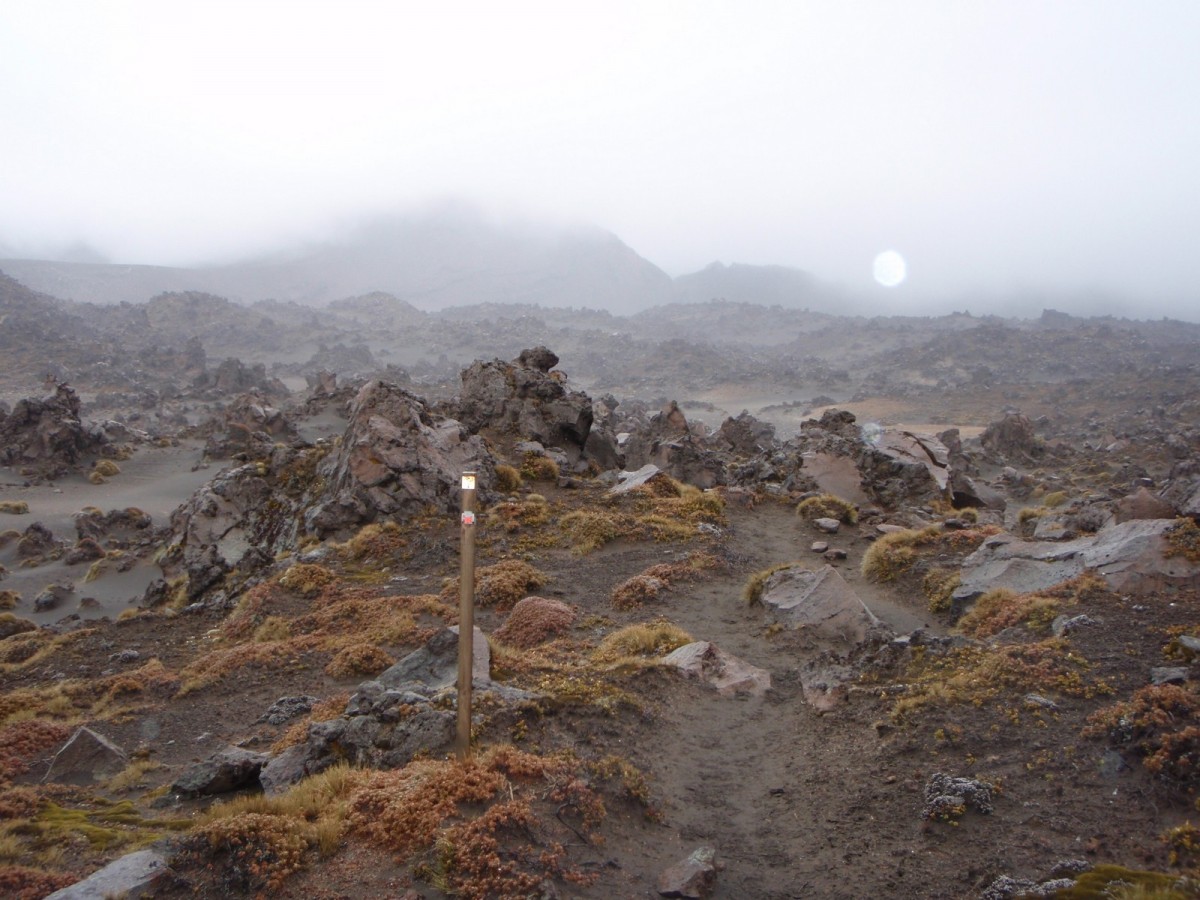
After a very windy, wet night we arose on a wet morning. From the Ketetahi Hut the first section involved backtracking along the previous day’s route around the Blue Lake, and then heading into what can only be described as moonscape. Luckily for us the weather on the previous day had been clear, so we did not miss out on the views when backtracking, which were obscured by clouds and mist. However, despite being wet and freezing, nothing could dampen our spirits as we walked over old lava flows and the only desert in New Zealand. The rain persisted along the whole of the 8.5km to the Oturere Hut and did not clear until late afternoon. We were then blessed with a beautiful view of melting snow on Mt Ngauruhoe, a huge waterfall and valleys filled with lava rocks.
On day four we awoke to a beautiful day with bright morning sunshine and clear views of the summits of Mt Ngauruhoe and Mt Ruapehu. This part of the trek goes over more of the unusual desert landscape. We crossed a few small streams, all the time enjoying magical mountain views. We then headed into a dark green, mossy forest, crossed a river by a footbridge and had a hard climb up and out of the valley. The Waihohonu Hut is not far from the valley crossing, and made for a peaceful lunch stop. We decided that we had had enough of the hut camp sites and continued after lunch to pitch our tent in the wild. The regulations require that tents are pitched at least 500m from the track, and we found a wonderful secluded spot by the river.

What a contrast in weather this hike has been. Day four was like a hot summer day, after we had been through hail and snow. What a place!
We rose early to try to beat the heat on another sunny day, with a 15km hike ahead of us to Whakapapa Village This final day goes through similar terrain to day one; exposed moorlands with lots of ups and downs. The dry weather made it easier to handle the creeks, mud and slush, but was a very hot, exposed hike. All day we had the most magnificent views of Mt Ruapehu and Mt Ngauruhoe. The track circles up towards Lower Tama Lake and then offers the options of heading directly to Whakapapa Village or diverting for an hour or so to the Upper Tama Lake. We opted to go straight ahead, as the thought of a cold beer and a scrumptious lunch at the bar of the Chateau Hotel was calling! The final section of the track brings you to the top of the Taranaki Falls, where there is a choice of taking the high or the low track to the Village. To take in the full view of the Falls it is better to take the low track, so we walked the final two kilometers along a beautiful shady track alongside the river.
To sum up this ‘tramp’:- If you are prepared to do it, you may be rewarded by seeing some of the most amazing, spectacular and wonderful scenery in the world in the space of just a few days—but be warned, the weather is fickle! We hope that you are lucky enough to have the weather gods on your side, but if they are not, there is always the chance you will see nothing at all!
For any who interested in finding out more about the Northern Circuit click here.